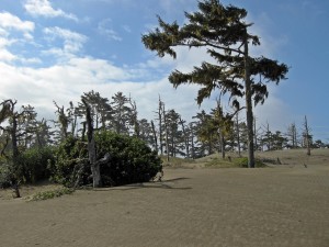
The Samoa Peninsula’s dune system is one of the most interesting and unusual environments in the region. It’s a dynamic landscape that, through restoration efforts, is returning to its natural splendor. This hike traverses both old, forested dunes and young, sparsely- or un-vegetated ones; both types support unique and distinctive plant communities. It starts at Friends of the Dunes’ Humboldt Coastal Nature Center, well worth a visit in its own right. The southern (HCNC) trail junctions are marked but the trail names aren’t indicated; the northern (federal) ones are color coded.
Friends of the Dunes: info@friendsofthedunes.org, 707-444-1397
Ma-le’l Dunes Cooperative Management Area: 707-825-2300 (Bureau of Land Management Arcata Field Office)
Humboldt Bay National Wildlife Refuge: denise_seeger@fws.gov, 707-733-5406


Lead a bird watching hike at the dunes yesterday. It was spectacular, with many birds, but also LOTS of mosquitoes. Beware of the mosquito factor from April-July depending on the standing water conditions.
The “unsigned trail in the forest” at mile 5.4 is called the Vou’gul Trail on the new Ma-le’l Dunes brochure map.
Due to beach erosion and dune buildup, the sign at the west end of the Kimuk Trail (mile 2.5) is just about impossible to see from the beach. The coordinates are N 40° 52.723’, W 124° 09.445’. Also, the property to the north of the hike is the Lanphere Dunes Unit of Humboldt Bay NWR, not “Lanphere Dunes NWR” as shown on the map.