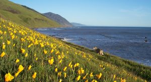
King Range and Shelter Cove Area

Dominated by the 68,000-acre King Range National Conservation Area (KRNCA), the over 100 miles of trails in the KRNCA are generally too remote and rugged to be considered short day hikes. The day hikes in this region tend to be longer and are included in Volume 1. Several walks along the Lost Coast, accessible from Mattole Road, are in this section. Conklin Road just east of Petrolia and the short walk to Punta Gorda south from the mouth of the Mattole River, some walks in Shelter Cove, and the beautiful walk from the Needle Rock Visitor Center to Bear Harbor in Sinkyone Wilderness State Park round out the selections in this region. Savvy readers will wonder at the inclusion of any walks in the Sinkyone as this 7,500-acre park lies completely in Mendocino County. However, realistically it is only accessible from Humboldt County.
The coastal mountains throughout this area shoot up steeply from the coastline, evidence of the tectonic forces at work here. King Peak, the tallest point in the range at 4,087’, is just 3 miles from the ocean. In addition, these mountains are battered by intense winter storms that have further sculpted the terrain. The result is a dramatic and distinctive topography.
- Steamboat Rock to Sugar Loaf Island (Cape Mendocino)
- McNutt Gulch/Creek
- Conklin Creek Road
- Mattole River to Punta Gorda
- Shelter Cove
- Short Loop
- Bill Franklin Nature Trail and Sea Foam option
- Sinkyone – Needle Rock Visitor Center to Bear Harbor
- Sinkyone Needle Rock Visitor Center to Whale Gulch


Leave a Reply