An independent publisher of web and print media. Printed ♻️ in the 🇺🇸.

Back Country Press logo

Cart

  • Classes
    • Arborist CEUs
  • Products
    • Books
    • Gift Card
    • Book Resources
    • Sale Items
    • Posters
    • ID Guides
    • Free Downloads
    • Hats
  • Authors
  • Blog
    • Podcast
  • About
    • Calendar
    • Vendor Sales
    • Newsletter
    • Find Our Books
  • My account
    • Orders
    • Downloads
    • Checkout
    • Lost Password
    • Login
Home » Hikes in Hiking Humboldt Volume 1 » Hike 32: Miller Loop

Hike 32: Miller Loop

DSCN3941

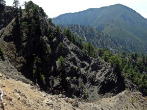
The north end of the King Crest Trail provides intermittent, breathtaking views to the east and west as well as south to King Peak as it passes through various vegetation types including extensive stands of chaparral and madrone and burned forest. The trail is very narrow and steep in some places, with steep drop-offs. About half the hike is Miller Loop, which drops steeply to Miller Spring at the headwaters of Honeydew Creek. The burned areas are loaded with wildflowers in spring and summer; beware of rattlesnakes in warm weather.

King Range National Conservation Area: 707-986-5400

Bird Lists
Book Resources
  • Hiking Humboldt Volume 1 book
    Hiking Humboldt Volume 1 book
    $24.95
    Add to cart
  • Hiking Humboldt Volume 1 book + eBook
    Hiking Humboldt Volume 1 book + eBook
    $34.95
    Add to cart
  • Hiking Humboldt Volume 1 eBook
    Hiking Humboldt Volume 1 eBook
    $15.95
    Add to cart
  • GPX Tracks: Hiking Humboldt Volume 1
    GPX Tracks: Hiking Humboldt Volume 1
    $9.95
    Add to cart

Leave a ReplyCancel reply

Events

Join Our Newsletter

* indicates required

Our most recent Podcast

Trivia Challenge: Wildflowers of the Klamath Mountains

https://backcountrypress.com/podcast-player/21109/trivia-challenge-wildflowers-of-the-klamath-mountains.mp3

Download file | Play in new window | Duration: 19:11 | Recorded on July 8, 2022

Subscribe: Apple Podcasts | Google Podcasts | Spotify

backcountrypress

Backcountry Press
>> Papoose Lake Revisited << In November 2008, I >> Papoose Lake Revisited <<

In November 2008, I made my first trip to Papoose Lake in the Trinity Alps Wilderness. That trip inspired my first blog post, with much writing to follow.

This first post was more about geology than plants because of the unique geologic character of the Papoose Lake Basin.

This month, almost 15 years later, I returned to Papoose Lake to conduct vegetation surveys as part of our Klamath Mountains Vegetation Mapping Project.

In many ways the basin is the same but in others changes are afoot.

Keep reading at our LI N K for reflections on 15 years of blogging through the eyes of a Klamath Mountain lake basin.

- Michael @michael.kauffmann

“In all the years I have spent standing or sitting on the banks of this river, I have learned this: the more knowledge I have, the greater becomes the mystery of what holds that knowledge together, this reticulated miracle called an ecosystem.”

- Barry Lopez, The Naturalist

#foxtailpine #klamathmountains #trinityalps #californianativeplants #wilderness #changeistheonlyconstant
💥HOT OFF THE PRESS: Hiking Humboldt Vol. 1 (2nd 💥HOT OFF THE PRESS: Hiking Humboldt Vol. 1 (2nd edition)

58 DAY HIKES IN NORTHWEST CALIFORNIA

The 2nd edition of this favorite guide book is filled with Fresh Maps, Additional Hikes, & Stunning Photos:

• Primeval forests harboring the world’s tallest trees.

• Sea cliffs, pristine beaches, and towering coastal sand dunes.

• Mountain prairies, meadows, and vistas.

• Rivers, lakes, lagoons, and bays.

• Bears, elk, seals, otters, and birds galore.

• And solitude – lots and lots of solitude.

Humboldt County offers all this and much more to the intrepid hiker.

Hiking Humboldt Volume 1 by Kenneth M. Burton presents descriptions, directions, accurate maps (including elevation profiles), and photos of hikes that are 5-15 miles in length throughout Humboldt County, CA.

• • • • •
SALE ENDS 9/10: get the eBook for free with your paperback purchase from @backcountrypress 🙌
• • • • •

In the seven years since we published the first edition of “HHV1,” we have heard from all sorts of Humboldtians who use the book as a hiking challenge — a checklist to complete them all. We hope this 2nd new & improved edition inspires even more people to do the same. We’d love to hear about your adventures —  tag #hikinghumboldt!

Have fun out there,
Michael & Allison

📘 Pick up your copy at our L I N K or find it at your favorite local shop: @eurekabooks @booklegger_eureka @northtownbooks @eurekanaturalfoods @northcoastcoop @blakesbooksmckinleyville

(Be in touch if your shop would like to carry this title as well!)

#humboldtmade #madeinhumboldt #humboldt #humboldtcounty #eurekaca #arcata #trinidadca #ferndale #sohum #lostcoast #northerncalifornia
FRUIT FLY TRAP TEST (🪰couldn’t not nerd out o FRUIT FLY TRAP TEST
(🪰couldn’t not nerd out on this fruit season outbreak)

Was really rooting for the Pinguicula!!

(Just trying to protect the peaches, @neukomfamilyfarm! 🙏❤️)

#fruitflytrap #scienceiseverywhere #carnivourousplant #pinguicula #harvestseason
🏆 Champion Klamath Foxtail Pine! (🌲 Pinus b 🏆 Champion Klamath Foxtail Pine!

(🌲 Pinus balfouriana subspecies balfouriana)

In 2010, I first found this tree while backpacking through the Trinity Alps Wilderness in far northern California.

Just last week, thirteen years later, my 11 year old son Sylas and I returned with tools to officially measure and nominate this tree.

While points fell just short of the overall champion, it is the second largest foxtail pine known and the largest of the subspecies of the Klamath foxtail pine.

It measures 24’ circumference 84’ tall 44’ crown spread for 383 AF points.

(I know what you’re thinking, but that actually stands for American Forest points. 🙃)

Tap our L I N K for the full story and learn how to measure a tree.

Klamath foxtail pines exist above 6500’ in the Klamath Mountains, often on serpentine soils. Find the one spot in this region you can actually drive to one in our book Conifer Country.

Foxtail pines are relatives of the Great Basin bristlecone (Pinus longaeva) and Rocky Mountain bristlecone (Pinus aristata). However, foxtail pines are endemic to California’s Sierra Nevada and Klamath Mountains. 

The best way to see this species is to hike to them. This particular tree required my son and I to do a 30 mile backpacking trip. It was full of wonder and beauty!

- @michael.kauffmann 

#foxtailpine #pinusbalfouriana #klamathmountains #conifers #conifercountry #californianativeplants #endemic #serpentine #pnw #pnwonderland #backpacking #trinityalps #wilderness #likefatherlikeson #treemagic #bigtree
🤩🎉🤩 You’re looking at the @northcoastjo 🤩🎉🤩 You’re looking at the @northcoastjournal’s pick for Best Local Author with the proprietor of the Best Bookstore @booklegger_eureka: @michael.kauffmann & Jen McFadden!

Such an honor, thank you all for your support! I know creating an account to vote was an annoying little hurdle, so extra thanks for leaping over it to cast yours! 💙

Also, how about the @cityofeureka’s Friday Night Market?! Talk about a vibrant little city by the sea!

#thankyou #iloveeureka #eurekacalifornia #independentbookstore #independentpublishing #humboldtcounty #humboldt #madeinhumboldt #humboldtmade
💎Orchid garden along the Smith River’s South 💎Orchid garden along the Smith River’s South Fork💎

The Smith is the most undeveloped and protected river remaining in California, and the largest completely undammed river from source to sea in the state. Much of the watershed features serpentine formations of the Josephine Ophiolite, and large areas are suited to rare plant life that thrives in harsh settings and in soils containing metals and minerals that are not conducive to typical forest growth.

The South Fork comes from higher elevations of the Siskiyou Wilderness where snow melt lingers and contributes to the basin’s highest flows through the spring.

Much of the Smith’s quality is attributed to nearly all the watershed being in public ownership as the Smith River National Recreation Area with legislated priorities on land and water protection. In addition, all of the 18 mile main stem and 320 miles of tributaries were designated as National Wild and Scenic Rivers in 1981.

This marked the first time that the streams of virtually an entire river basin were together designated in the National Wild and Scenic Ricer System as part of a watershed-wide approach.

💎 Stream Orchid, AKA Chatterbox (Epipactis gigantea)

Where have you found these stunning (and well camouflaged!) orchids blooming this summer? They’re surprisingly common, though often go unnoticed because they blend in so well with their surroundings. 

Featured 📕: Wildflowers of California’s Klamath Mountains

#wildandscenic #orchid #californianativeplants #serpentine #smithriver #klamathmountains #wilderness #wildcalifornia #delnortecounty #northerncalifornia
Load More... Follow on Instagram

Product tags

Botany Butterflies California Conifers Desert ecology ectotherms explorations Fire Fire Ecology Forest pathogens Fungi Geology Hiking Hiking Guide Humboldt County Identification Card Invertebates Klamath Mountains Klamath Mountians Lassen Volcanic National Park Literature Mammals Natural History Oregon Pacific Crest Trail pathogens Pines Plant Exploring Plants redwood forest Rivers road guide Seaweed Trinity Alps Washington

GIft Card from BCP

bookstore

Subscribe to the Backcountry Press Blog

Enter your email address to subscribe to this blog and receive notifications of new posts by email.

Join 223 other subscribers

FREE SHIPPING on orders of $75 or more Dismiss