Order $75 or more and get FREE SHIPPING Dismiss

An independent publisher of web and print media. Printed ♻️ in the 🇺🇸.

Back Country Press logo

Cart

  • Classes
    • Arborist CEUs
  • Products
    • Books
    • Gift Card
    • Book Resources
    • Sale Items
    • Posters
    • Games
    • ID Guides
    • Free Downloads
    • Hats
  • Authors
  • News
    • Podcast
  • About
    • Calendar
    • Vendor Sales
    • Newsletter
    • Scholarships
    • Find Our Books
  • My account
    • Orders
    • Downloads
    • Checkout
    • Lost Password
    • Login
Home » Hikes in Hiking Humboldt Volume 1 » Hike 52: Grizzly Camp to Horse Linto Creek

Hike 52: Grizzly Camp to Horse Linto Creek

Grizzly Camp to Horse Linto Creek

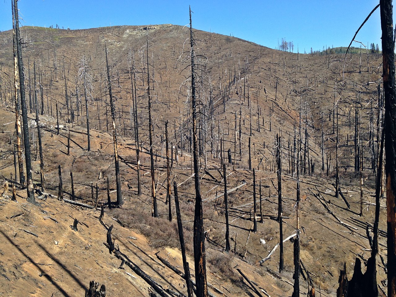
The Grizzly Camp to Horse Linto Creek section of the Horse Ridge Trail traverses a post-apocalyptic landscape, the product of a series of devastating wildfires. After a gradual one-mile climb through the most intensively burned stretch, the trail drops very gradually to the headwaters of Horse Linto Creek, crossing several small drainages along the way. The trail peters out beyond that but you can bushwhack up the last half mile to the saddle for a nice view north across the Soldier Creek canyon to Devil’s Backbone. As with any hike through a burn, be prepared to scramble over logs and push through encroaching brush.

Six Rivers National Forest Lower Trinity Ranger District: 530-629-2118

Bird Lists
Book Resources
  • Hiking Humboldt Volume 1 book
    Hiking Humboldt Volume 1 book
    $24.95
    Add to cart
  • Hiking Humboldt Volume 1 book + eBook
    Hiking Humboldt Volume 1 book + eBook
    $34.95
    Add to cart
  • Hiking Humboldt Volume 1 eBook
    Hiking Humboldt Volume 1 eBook
    $15.95
    Add to cart
  • GPX Tracks: Hiking Humboldt Volume 1
    GPX Tracks: Hiking Humboldt Volume 1
    $9.95
    Add to cart

Comments

  1. Chris Valle-Riestra says

    November 12, 2019 at 2:20 am

    This stretch of trail has received no Forest Service maintenance in several years. It remains passable for experienced and patient hikers to Lipps Camp. Parts of the route are fairly heavily overgrown with brush, and there are deadfalls. Some sections of forest have been spared destruction by fire, and are quite scenic, with the trail easy to follow. Past Lipps Camp, a hiker’s report from June 2018 said that there was an impenetrable “sea of brush.” It may be possible to bypass the blockage by traveling crosscountry, departing the trail to the west below Lipps Camp, ascending following close to the bed of Horse Linto Creek, and then climbing to the ridge line where the creek approaches it closely, to rejoin the trail. This is a distance of a little under half a mile. Close study of Google Earth imagery is advised for anyone thinking of making this attempt. Once the trail gains the top of the ridge to the west, it appears to open up again. However, parts of the route passing Devils Hole, to the junction with the Tish Tang Trail are quite vague.

    The Lipps Camp Trail, which branches north past Lipps Camp, burned heavily in the 1999 Megram Fire and subsequent fires. It can be seen on aerial imagery to be severely overgrown with brush.

    Reply
  2. Mark Fritzke says

    November 12, 2019 at 10:47 am

    The “post-apocalyptic landscape” is now green and overgrown with 8-ft tall brush. I just hiked north from Grizzly Camp and was pleased to see trail clearing almost to Lipps Camp. The trail north of Lipps is totally overgrown and gone.

    Reply
  3. Chris Valle-Riestra says

    August 28, 2020 at 5:20 pm

    This trail is currently closed to the public, due to the ongoing Red Fire.

    Reply
  4. Susan Nolan says

    October 10, 2024 at 7:52 pm

    Once you get past the initial uphill slog, an easy trail through partially burned forest. Yes it has greened up a lot since the photo was taken. I saw seven bears in three hours, six of them appearing to be smaller adults in pairs–maybe two year old litter mates still sticking together? All fled immediately upon sensing a human presence. What you won’t see is any other people. Pleasant camp near the end of the trail. Possible to hike up through Devils Hole to the old guard station on the ridge dividing New River and Trinity drainages and that trail network.
    I’ve gone out there twice and would like to go again.

    Reply

Leave a Reply Cancel reply

Your email address will not be published. Required fields are marked *

Events

Join Our Newsletter, get 10% off

* indicates required

Our most recent Podcast

Trivia Challenge: Wildflowers of the Klamath Mountains

https://backcountrypress.com/podcast-player/21109/trivia-challenge-wildflowers-of-the-klamath-mountains.mp3

Download file | Play in new window | Duration: 19:11 | Recorded on July 8, 2022

Recent Posts

  • Updated Field Guide Details the Science and Story of Berryessa Snow Mountain National Monument Region January 11, 2026
  • More Than a Bookstore: Standing with Northtown Books January 3, 2026
  • When the Rain Truly Fell: Remembering the Mother of All Storms December 15, 2025
  • California Trees Wins National Outdoor Book Award November 14, 2025
  • New Book Explores the Environmental History of the San Francisco Bay Area October 27, 2025

Product tags

Botany California Cascadia Conifers Desert ecology ectotherms explorations field guide Fire Fire Ecology Forest pathogens Fungi Geology Hiking Hiking Guide History Humboldt County Identification Card Invertebates Klamath Mountains Klamath Mountians Lassen Volcanic National Park Literature Mammals mushrooms Natural History Oregon Pacific Crest Trail pathogens Pines Plant Exploring Plants redwood forest Rivers road guide San Francisco sea vegetables Seaweed Trees Trinity Alps Vernal Pools Washington wildflowers

RSS Follow Backcountry Press updates

GIft Card from BCP

bookstore