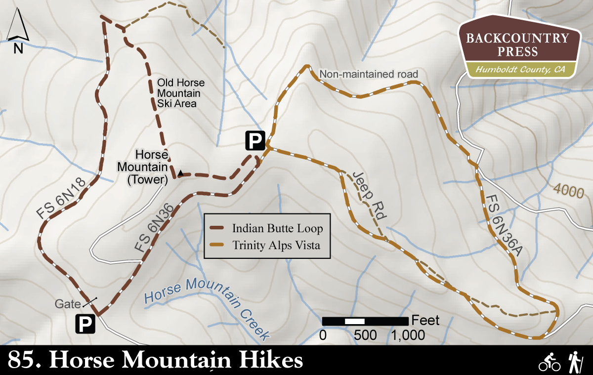
Although there are actually no established trails in the Horse Mountain area, a number of interesting and view-rich walks are possible. The routes generally rely on maintained or abandoned Forest Service roads. Many of these walks occur in the 1,100-acre Horse Mountain Botanical Area, a designation that recognizes the unique nature of these high elevation plant communities of Jeffrey pine, western white pine, and Port Orford-cedar and other conifers. This area has been subjected to a high level of human impact as evidenced by the phalanx of communications equipment topping Horse Mountain itself, the old ski slope on Horse Mountain’s north face, the nearby remnants of the Horse Mountain Copper Mine, and, all too often, shell casings and other trash.
In recent years, a coalition of trail advocates has been working informally to create an identifiable network of walking routes in the Horse Mountain area. Even though the Forest Service has not permitted the addition of any official signage or supported trail development, the coalition has identified several very pleasant walks that are reflected below. In all cases some level of route finding is involved and a map of Six Rivers National Forest is helpful.
Getting there: Proceed north on US 101 for 9.5 miles taking Exit 716A (CA 299) east toward Weaverville/Redding. In 28.0 miles take the Titlow Hill Road that exits right from Berry Summit. Follow Titlow Hill road for 4.6 miles to the broad Horse Mountain parking area that also serves as the junction for several roads. Substantial parking exists in this area for the Horse Mountain Mine walk. Turn left to reach the Indian Butte Loop walk and the Trinity Alps Vista walk. Continue straight along Forest Service 1 for the Cold Spring walk (Hike #86) and the Spike Buck Mountain walk (Hike #87). Approximate driving time, 1 hour.
Trinity Alps Vista Loop
Description: This relatively short walk offers outstanding views of the Trinity Alps, Mt. Shasta, the Bald Hills and the Klamath Mountains, the Brush Mountain Fire Lookout, as well as nearby geographical features. Although unsigned, the route utilizes a combination of a lightly used Forest Service road, rough jeep road, and inactive logging road that circumnavigate an east-trending ridge of Horse Mountain. The route concludes with an aerobic uphill leg.
Indian Butte Loop
Description: Like virtually all walks in the Horse Mountain area, the Indian Butte Loop is unsigned and necessitates some comfort with route finding. That being said, this is not a complicated walk and the ever-present landmark of the communication equipment atop Horse Mountain makes it difficult to get lost. The out-bound route follows a forest service road with periodic views to the west; the return includes a steep climb through the old Horse Mountain ski area, now with twenty-year old conifers dotting the slopes. From here the views of the Trinity Alps and distant Mt. Shasta open up. The final leg has southern views of Titlow Hill and the remnants of Horse Mountain Copper Mine. These west and northwest slopes of Horse Mountain include a healthy representation of Port Orford-cedar.


Leave a Reply