Order $75 or more and get FREE SHIPPING Dismiss

An independent publisher of web and print media. Printed ♻️ in the 🇺🇸.

Back Country Press logo

Cart

  • Classes
    • Arborist CEUs
  • Products
    • Books
    • Gift Card
    • Book Resources
    • Sale Items
    • Posters
    • Games
    • ID Guides
    • Free Downloads
    • Hats
  • Authors
  • News
    • Podcast
  • About
    • Calendar
    • Vendor Sales
    • Newsletter
    • Scholarships
    • Find Our Books
  • My account
    • Orders
    • Downloads
    • Checkout
    • Lost Password
    • Login

Bumpass Hell Trail

August 26, 2019 by Backcountry Press 2 Comments

Geology of the Lassen Country

Bumpass Hell Trail
Bumpass Hell Hike Map

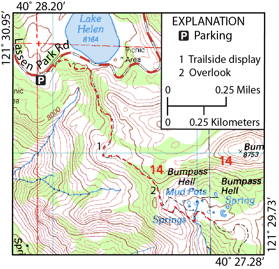
The Bumpass Hell Trail is one of the most popular destinations in the Lassen Country. The trailhead is at the large parking area 0.25 mile (0.4 km) east of Lake Helen. The trail traverses the dacite of Bumpass Mountain for the majority of the hike. Also, note the well-preserved glacial polish and striae in the dacite alongside the first few hundred yards of the trail. They were created by the glacier that started from the Lake Helen cirque. At the viewpoint where the trail turns east, about 0.5 mile (0.8 km) from the trailhead, it crosses briefly into andesite of Mount Diller. Here a National Park Service trailside interpretive display shows a model of Brokeoff Volcano before erosion.

Trailhead: Bumpass Hell trailhead parking lot
Distance: 3.0 miles (4.8 km) round trip
Key Geologic Features: Hot springs, clay-altered bedrock

West Pyrite Pool and Big Boiler along the Bumpass Hell Trail.

At 0.9 mile (1.4 km) the trail comes to an overlook that provides a great view of Bumpass Hell. In late spring and early summer, when the trail usually opens, steam can be seen rising off the hot pools. Rising steam is always present but in the summer it is not as visible. Note the discolored water and rocks turned to clay by the acidic hydrothermal waters.

From the overlook the trail descends 160 feet (49 m) in 0.6 mile (1 km) through dacite of Bumpass Mountain explosion breccia into the Bumpass Hell basin. During the descent, the stench of hydrogen sulfide, characterized by its rotten egg smell, will be apparent.

  • Geology of the Lassen Country paperback + eBook
    Geology of the Lassen Country paperback + eBook
    $29.95
    Add to cart
  • Geology of the Lassen Country eBook
    Geology of the Lassen Country eBook
    $14.95
    Rated 5.00 out of 5 based on 1 customer rating
    Add to cart
  • Geology of the Lassen Country
    Geology of the Lassen Country
    $24.95
    Rated 5.00 out of 5 based on 1 customer rating
    Add to cart

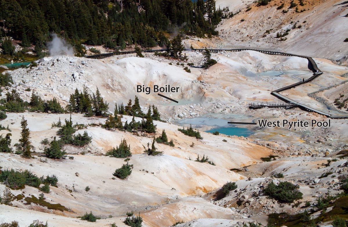
The National Park Service has constructed boardwalks that safely lead hikers through the hydrothermal area. What appears to be an area safe to walk on is often underlain by scalding hot water beneath a thin crust that cannot support humans. Therefore, for your safety and to prevent damage to the delicate features in the hydrothermal area, PLEASE stay on the boardwalks.

Much of the volcanic bedrock underlying the 0.05 square mile (0.13 square km) hydrothermal area is strongly altered to opal (water-bearing silica) and kaolinite, a white clay mineral. The orange and yellow surface coatings are sulfate minerals. Many steam vents are lined with native sulfur. Pyrite can be seen as black scum floating on the surface of the pools, vent and discharge channels, and dispersions in the black or gray mud pots.

View the Park Service Description

This trail guide showcases the geologic history of the Lassen Country and is not intended to be a rock and mineral collecting guide. Please note that collecting natural features in Lassen Volcanic National Park is illegal and can be done only with a special collecting permit.

View Book’s Online Resources

Filed Under: Geology, Hiking, Lassen Country, Lassen Geology Tagged With: fumeroles, Hot Springs, mudpots

Comments

  1. Heather Shumard says

    August 26, 2019 at 8:35 pm

    I believe the Bumpass Hell trail is closed for rehabilitation this summer. There is an alternate trail. The directions can be found at the NPS website. The main trail is expected to reopen in late September.

    Reply
    • Backcountry Press says

      August 27, 2019 at 8:37 pm

      Thanks Heather — I hear it will be open again soon.

      Reply

Leave a Reply Cancel reply

Your email address will not be published. Required fields are marked *

Events

Join Our Newsletter, get 10% off

* indicates required

Our most recent Podcast

Trivia Challenge: Wildflowers of the Klamath Mountains

https://backcountrypress.com/podcast-player/21109/trivia-challenge-wildflowers-of-the-klamath-mountains.mp3

Download file | Play in new window | Duration: 19:11 | Recorded on July 8, 2022

Recent Posts

  • Updated Field Guide Details the Science and Story of Berryessa Snow Mountain National Monument Region January 11, 2026
  • More Than a Bookstore: Standing with Northtown Books January 3, 2026
  • When the Rain Truly Fell: Remembering the Mother of All Storms December 15, 2025
  • California Trees Wins National Outdoor Book Award November 14, 2025
  • New Book Explores the Environmental History of the San Francisco Bay Area October 27, 2025

Product tags

Botany California Cascadia Conifers Desert ecology ectotherms explorations field guide Fire Fire Ecology Forest pathogens Fungi Geology Hiking Hiking Guide History Humboldt County Identification Card Invertebates Klamath Mountains Klamath Mountians Lassen Volcanic National Park Literature Mammals mushrooms Natural History Oregon Pacific Crest Trail pathogens Pines Plant Exploring Plants redwood forest Rivers road guide San Francisco sea vegetables Seaweed Trees Trinity Alps Vernal Pools Washington wildflowers

RSS Follow Backcountry Press updates

GIft Card from BCP

bookstore